Drone Inspection for Water Utility Infrastructure: Easements, Treatment Plants, and the Pipes You Cannot See
How drone capture supports water utility asset management — easement and ROW monitoring, treatment plant inspection, leak indication, and where the technology helps versus where buried infrastructure still needs other tools.
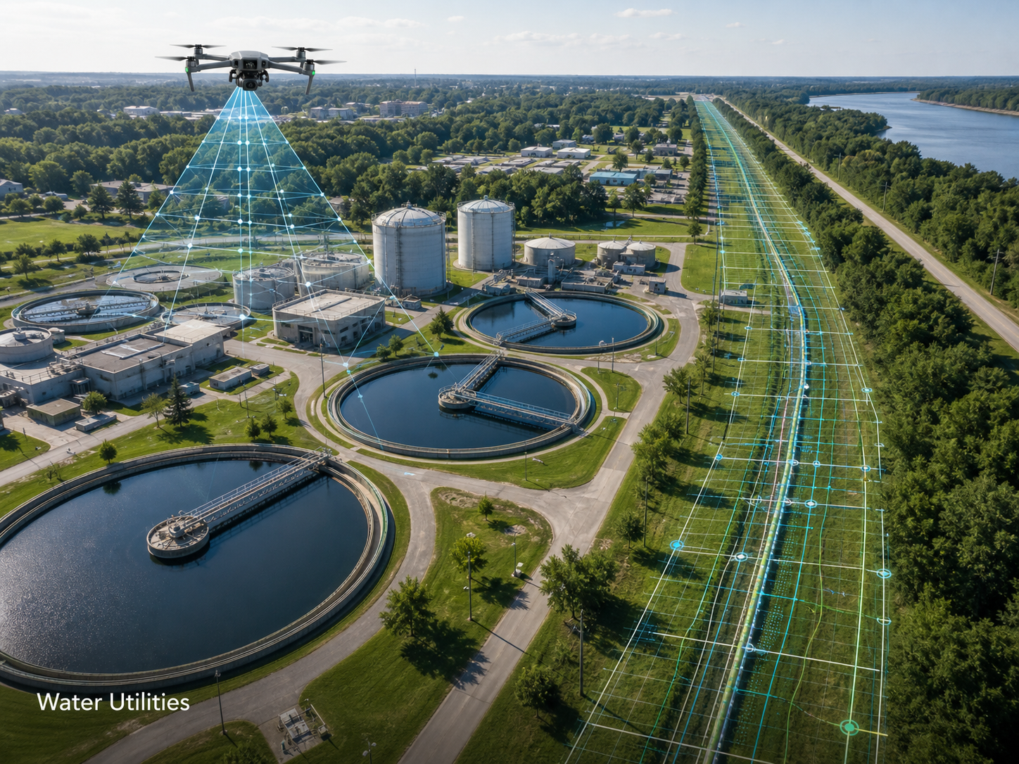
Water utilities operate some of the most distributed and least visible infrastructure in the asset world. The pipes are buried, the easements run across landholdings the utility does not own, and the inspection budget per mile is a fraction of what comparable energy infrastructure receives. Drone capture has a clear and growing role in this environment — not as a replacement for in-pipe inspection or pressure monitoring, but as the surface-condition and corridor-visibility layer that has been missing from most asset programs.
This post is about where drone work adds genuine value for water utilities, where the technology is regularly oversold, and what to scope into a program that produces operational data rather than aerial photos.
The backdrop matters
The condition of US water infrastructure is well-documented. The American Water Works Association has listed ageing infrastructure as the industry’s top concern in its annual survey for over a decade. The numbers behind that concern are striking: a water main break occurs every two minutes on average in the US, losing roughly 6 billion gallons of water per day and 2.1 trillion gallons annually through distribution losses. The distribution network was built largely in the 1970s, with some pipe stock dating back 125 years.
That backdrop creates a clear operational gap. Utilities know their network is deteriorating; what they need is a sustainable way to monitor the surface condition of their easements, identify visible failure indicators, and capture treatment and pump station condition without sending crews to every site every cycle.
Drone capture fills part of that gap. It does not fill all of it, and the right scoping conversation is honest about where the line is.
Where drone capture clearly adds value
Four water utility applications consistently produce strong return on a drone program.
Easement and ROW monitoring. Water utilities typically have easements running across thousands of landholdings — agricultural, residential, commercial, conservation. Periodic aerial capture of those corridors identifies encroachment (sheds, fences, plantings over the easement), access issues, and surface disturbance indicating possible underground activity. The capture also produces a defensible record for landowner conversations that previously relied on memory or sporadic ground visits.
Treatment plant and pump station condition. Large water and wastewater treatment sites have substantial above-ground infrastructure — tanks, weirs, pump houses, electrical and chemical handling. Aerial capture documents condition without the access coordination needed for elevated ground inspection. Specialised providers can conduct full plant inspections in hours rather than days, with comprehensive visual records that support maintenance planning.
Surface evidence of buried failures. Drone-derived imagery — particularly when combined with thermal capture under the right conditions — can identify surface wetness, vegetation greening, and ground disturbance that may indicate underground leaks. This is screening, not diagnosis. Confirmation needs acoustic, pressure, or in-pipe methods. But identifying candidate locations from the air is meaningfully faster than identifying them on foot.
Civil works progress and acceptance. New pipeline installations, treatment plant upgrades, and major maintenance works all produce aerial-capturable progress and as-built records. The deliverable becomes part of the asset record, supporting warranty, regulatory, and contractor management workflows.
Where the technology is oversold
The honest part of any water-utility drone conversation is what the technology does not do.
Thermal does not see through the ground. Surface thermal indication of a leak depends on the leak producing a measurable surface signature — temperature anomaly, wetness, or vegetation response. Deep, small, or slow leaks may not. A thermal flight that finds nothing is not proof of no leaks; it is proof of no surface-visible leaks under the inspection conditions.
Drone capture does not replace in-pipe inspection. CCTV crawlers, smart-ball technology, and sensor networks remain the right tools for internal condition assessment. Drone work documents the surface and corridor; the pipes inside the trench need other methods.
A single thermal pass is not a leak survey. Useful surface leak indication usually requires controlled conditions (early morning, no recent rain, consistent ambient temperature) and multiple comparative passes. A one-off flight produces a snapshot, not a baseline.
“Water utility teams come to us asking about drone leak detection more often than any other application,” says Hunter Gray, founder of Overwatch Mapping. “We are honest with them — it is real, it is useful, and it is a screening tool, not a survey tool. The right framing is that the drone work identifies candidate locations faster, and the existing detection methods confirm. Used that way, the program is genuinely useful. Sold as a leak survey, it disappoints.”
That framing — drone capture as a faster screening layer that feeds the existing detection program — is where the technology fits cleanly into water utility operations.
The cost picture is favourable
The cost case is where drone programs land most quickly in water utility operations. Manual easement walks and treatment plant inspections carry significant labour, vehicle, and access costs. A drone program typically reduces these by 40 to 60% on comparable scope, with faster turnaround.
The widely-cited Macomb County, Michigan example is representative: the utility reduced inspection costs from $1 million every three years to $100,000 by moving to drone capture, with faster and more comprehensive results.
For smaller utilities, the absolute numbers are different but the proportional savings are similar. The constraint is often not the cost of the flight, it is the integration of the resulting data into the utility’s existing asset management system — which is where most of the upstream scoping conversation should focus.
What a working program scope looks like
A useful water utility drone program is structured around recurring cycles, not one-off projects. The most common structure we see in production is:
- Annual easement and ROW capture of the high-risk corridors — typically rural or environmentally sensitive easements where ground visibility is poor.
- Quarterly or semi-annual treatment site capture for major treatment plants and pump stations, with thermal capture on the electrical and mechanical assets.
- Targeted screening flights in response to specific concerns — pressure anomalies, customer complaints, billing pattern changes, weather events.
- Project-based capture for civil works, pipeline replacement, and major maintenance.
The annual easement capture is usually the highest-value recurring deliverable. It produces a comparable visual record across the network, identifies encroachment trends, and provides the documentation backbone for landowner and regulatory conversations.
Coordination realities
Water utility drone work has coordination requirements that are different from most other infrastructure work.
Landowner notification. Easements often run across private property where overflight is technically permissible but socially expected to be notified. A program should include a landowner notification protocol, particularly for residential easements.
Privacy management. Aerial imagery of residential easements captures houses, gardens, and vehicles. Image handling, blurring, and retention policies need to be in place before capture, not after a privacy concern surfaces.
Treatment plant safety integration. Active treatment plants have chemical handling, confined space, and electrical zones with strict access controls. Drone work integrates with the plant’s safety system the same way it would for substation work.
Permission for non-utility-owned infrastructure. Some water utilities depend on infrastructure they do not own (shared corridors, bulk transfer pipelines, multi-utility easements). Permission and notification structures need to be confirmed before capture.
“The technical drone work for a water utility is straightforward. The coordination work is what makes the program sustainable,” Gray notes. “The utilities who treat the landowner relationship as part of the program get a much smoother run than the ones who treat it as a friction point.”
A practical specification for water utility drone work
When commissioning drone work for water utility infrastructure, the scope should address:
- Asset and corridor list — which easements, which sites, in what priority.
- Recurring cadence — annual easement, quarterly site, plus event-driven.
- Deliverables per flight — orthomosaic, oblique image set, thermal capture where appropriate, change-comparison report against prior capture.
- Landowner notification protocol — who, when, how.
- Privacy and data handling policy — blurring, retention, access control.
- Integration target — asset management system, GIS, work order system.
- Screening flight provisions — how out-of-cadence flights are commissioned.
- Safety integration — for treatment plant and pump station work.
A scope that addresses these turns into a program that pays for itself in the first year on easement and treatment site work alone, and that builds a comparable visual record across the network over time.
The pipes that need replacement are the same pipes that needed replacement before the drone program started. What changes is the speed and consistency of identifying which assets to prioritise — and that is where the program earns its place in the asset management workflow.