Services
Drone mapping and inspection services for infrastructure teams.
Six service modules, each scoped against a specific operational outcome — from baseline mapping to repeatable change monitoring. Pick the one that matches the decision your team needs the data to support.
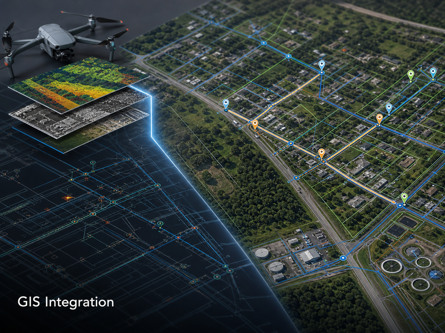 Service · 01 DRONE MAPPING
 Module 01
Drone Mapping & Orthomosaics
Geo-referenced, distortion-corrected aerial maps of sites and corridors. The base layer most of our other deliverables build on.
Best used for
- Site mapping for engineering and operations
- Asset and infrastructure documentation
- Corridor mapping for utilities and pipelines
- Construction progress documentation
- Land and environmental context capture
- Planning and maintenance reviews
What we capture
- High-resolution aerial imagery with overlapping flight paths
- Photogrammetry-ready capture for orthomosaic generation
- Site context and surface conditions where visible
- Asset location and orientation references
Deliverables
- Orthomosaic (GeoTIFF) at agreed ground sample distance
- Geo-referenced JPG imagery
- PDF map outputs for sharing and reporting
- GIS-ready files in your preferred CRS
- Annotated visual outputs where requested
Client inputs required
- Site location and corridor extents
- Required accuracy and CRS
- Access contact and induction requirements
- Any operational or airspace restrictions
Typical applications
 Service · 02 PIPELINE CORRIDOR SURVEYS
 Module 02
Pipeline Corridor Surveys
Continuous corridor mapping and inspection across pipeline easements and rights-of-way — capture, evidence, and reporting in one pass.
Best used for
- Oil and gas pipeline corridors
- Water pipelines and trunk mains
- Easement and right-of-way monitoring
- Encroachment and unauthorised activity checks
- Erosion, washout, and ground disturbance documentation
- Vegetation monitoring near alignment
What we capture
- Continuous corridor imagery at consistent overlap
- Access track condition references
- Vegetation and encroachment indicators
- Visible ground disturbance and drainage issues
- Surface-level asset context
Deliverables
- Corridor orthomosaic with location references
- Geo-tagged inspection imagery by segment
- Annotated issue location summary
- Inspection notes against the asset reference framework
- Change documentation against prior baseline (where available)
- Report-ready visual evidence pack
Client inputs required
- Corridor alignment and survey width
- Access points with named landholder contacts
- Induction and biosecurity requirements
- Required deliverables and file formats
Typical applications
 Service · 03 UTILITY
 Module 03
Utility & Substation Inspection
Visual condition imagery and site context for substations, switchyards, and access-constrained utility assets — coordinated with the asset owner's safety system.
Best used for
- Electrical substations and switchyards
- Utility compounds and asset yards
- Transmission support assets
- Access-constrained infrastructure
- Visual inspection support
- Maintenance planning
What we capture
- High-resolution visual imagery from agreed safe offsets
- Asset condition indicators visible from flight position
- Site layout and perimeter context
- Vegetation and access constraints
- Equipment top-side and elevated fitting references
Deliverables
- Structured inspection image set with asset references
- Annotated visual report
- Site orthomosaic where in scope
- Maintenance planning visuals
- Issue location references for follow-up
Client inputs required
- Site contact and safety officer details
- Agreed offsets from energised equipment
- Operational and induction requirements
- Asset reference framework for imagery labelling
Typical applications
 Service · 04 THERMAL
 Module 04
Thermal & Condition Inspection
Screening-grade thermal imagery for energised electrical assets, solar PV, and industrial process equipment — paired with visible-light context.
Best used for
- Electrical asset condition screening
- Solar and renewable infrastructure
- Building or industrial thermal anomalies
- Maintenance prioritisation support
- Supplementing existing visual inspection programs
What we capture
- Calibrated thermal imagery under appropriate load conditions
- Visible-light imagery paired to every thermal frame
- Location-referenced observations
- Comparative thermal views where relevant
Deliverables
- Thermal image set (JPG and radiometric TIFF where applicable)
- Paired visible-light image set
- Anomaly screening summary with location references
- Conditions log (ambient, weather, asset load)
- Follow-up inspection recommendations
Client inputs required
- Asset reference framework and load conditions
- Site contact and safety system requirements
- Operating state on the day of the flight
- Reviewer for screening output
Typical applications
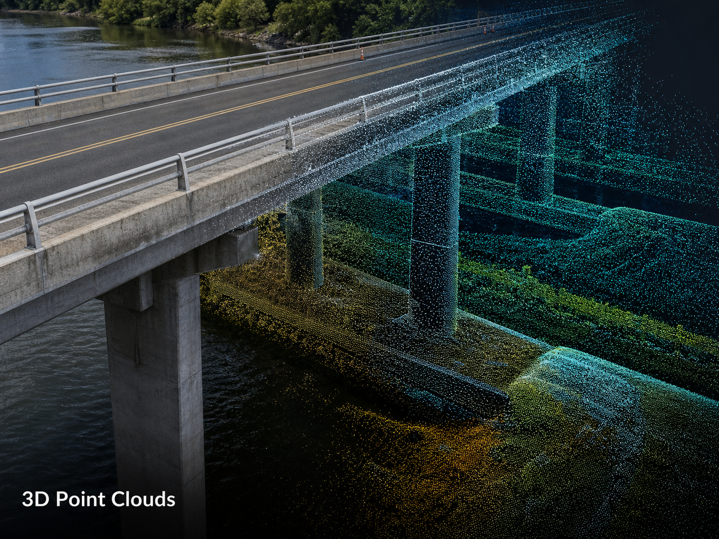 Service · 05 3D MODELS
 Module 05
3D Models & Digital Surface Data
Photogrammetry-derived 3D models, digital surface models, and point clouds for site visualisation, terrain context, and engineering planning support.
Best used for
- Site modelling and visualisation
- Volume and terrain context
- Engineering planning support
- Construction documentation
- Asset and infrastructure visualisation
- Change comparison across flights
What we capture
- Overlapping imagery for photogrammetry processing
- Surface and structural detail where suitable for the sensor
- Site geometry and surrounding context
- Ground control where accuracy requirements are scoped in
Deliverables
- 3D model (OBJ / FBX / GLB)
- Digital surface model (GeoTIFF)
- Point cloud (LAS / LAZ) where appropriate
- Model screenshots and visualisations
- Measurement-ready outputs where accuracy is agreed in scope
Client inputs required
- Site extents and required model coverage
- Accuracy requirements and CRS
- Required outputs and downstream software
- Ground control point placement where applicable
Typical applications
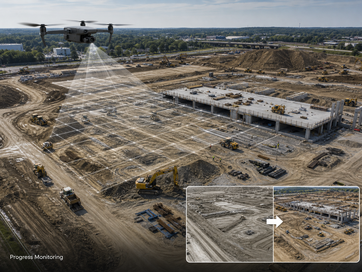 Service · 06 PROGRESS, CHANGE
 Module 06
Progress, Change & Compliance Monitoring
Repeatable, comparable aerial flights for capital works progress, maintenance programs, environmental obligations, and post-event documentation.
Best used for
- Construction and capital works progress
- Maintenance and inspection programs
- Environmental and land obligation reporting
- Contractor documentation
- Repeat site monitoring at defined cadence
- Before / after evidence around works or events
- Incident response documentation
What we capture
- Repeatable flight paths and capture parameters
- Visual asset condition references
- Site changes and contractor progress
- Access and compliance evidence
Deliverables
- Repeat orthomosaics at agreed cadence
- Progress reports against the prior baseline
- Before / after comparisons
- Change summaries with annotated visuals
- Stakeholder-ready documentation packs
Client inputs required
- Defined monitoring cadence and triggers
- Baseline flight specification for repeatability
- Required reporting format
- Storage and handover structure
Typical applications
Next step
Talk to us about your next mapping or inspection project.
Tell us the asset, the access conditions, and the deliverables your team needs. We will respond with a clear scope and an indicative plan.