Drone Response to Storms and Disasters: How Aerial Capture Compresses the Damage Assessment Timeline
How drones have changed the post-event damage assessment workflow for utilities and infrastructure operators — what the technology delivers in the first 48 hours, how it integrates with FEMA processes, and what operators should pre-position before the next event.
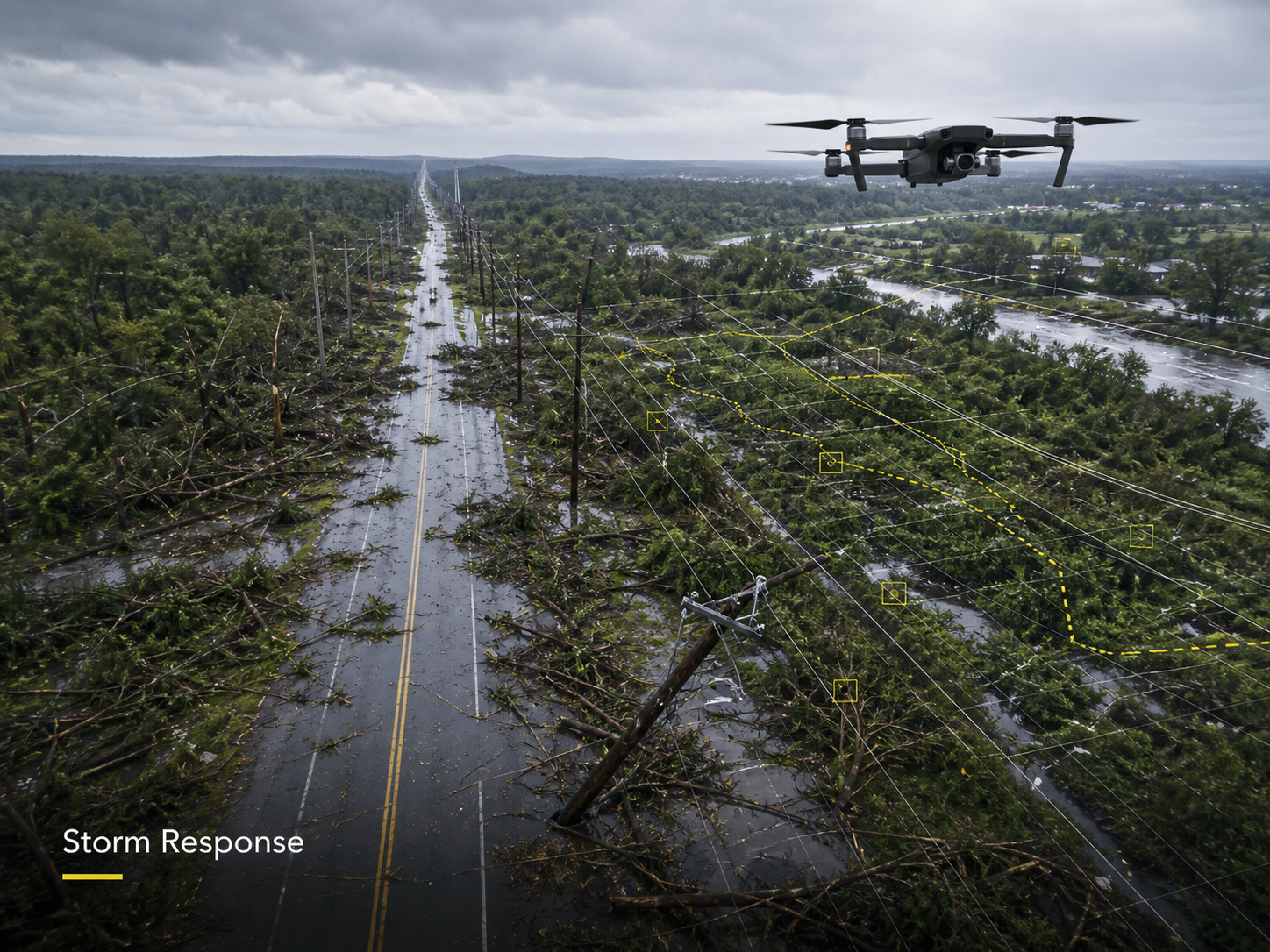
The post-event window is when the asset team’s information disadvantage is at its largest and most operationally costly. Crews cannot safely access affected areas, ground roads may be impassable, the asset condition record is suddenly out of date, and decisions about restoration priority, contractor mobilisation, and federal assistance applications depend on data that historically took days to produce. Drones have meaningfully changed that timeline.
This post is about how drone capture fits into modern storm and disaster response — what the technology produces in the first 24 to 48 hours, where it integrates with FEMA processes, and what infrastructure operators should pre-position so the capability is available when it is needed.
What changed
Traditional aerial damage assessment relied on commercial contractors with fixed-wing or helicopter assets, and typically waited 3 to 7 days for first reconnaissance — longer if airspace was restricted or weather lingered. Drone capability has compressed that into same-hour intelligence on accessible areas and same-day comprehensive assessment on most asset classes.
The 2017 hurricane season was the inflection point. CRASAR, the center for robot-assisted search and rescue at Texas A&M, led the largest civilian UAV deployment in any post-disaster response during Hurricane Harvey, completing 119 flights for flood inundation mapping and damage assessment. The pattern has been repeated and refined in every major event since, with Hurricanes Helene and Milton in 2024 seeing widespread deployment by utilities and emergency services across the southeastern US.
The current operational baseline is meaningful: drone-based damage assessment programs report up to 60% reduction in processing time and same-day preliminary damage assessments that accelerate federal assistance approval.
“The change is not that drones can fly after a storm — that has been true for years,” says Hunter Gray, founder of Overwatch Mapping. “The change is that the integration with the asset management workflow and with FEMA’s documentation requirements has matured to the point where the drone data is actually used to drive the response, not collected and reviewed three weeks later. That is what makes the capability operationally meaningful.”
The first 24 to 48 hours
The post-event drone workflow that delivers the most value is structured around three phases in the first 48 hours.
Phase 1 — Initial reconnaissance (0 to 12 hours after airspace re-opens). Rapid overflight of the highest-priority assets — substations, generation facilities, critical pipeline crossings, customer concentrations, suspected hot zones. The deliverable is a fast visual assessment to inform mobilisation priority. Imagery quality is less important than coverage speed.
Phase 2 — Comprehensive asset capture (12 to 36 hours). Structured capture across the affected portfolio — orthomosaic, oblique imagery, asset-specific close-ups. The deliverable is comparable to the pre-event baseline and supports both internal restoration decisions and external (regulatory, insurance, FEMA) documentation.
Phase 3 — Detailed event documentation (24 to 72 hours). Site-by-site capture of severely affected assets with structural, environmental, and access detail. The deliverable supports detailed restoration planning, insurance and warranty work, and post-event analysis.
The phasing matters because the value proposition is different in each. Phase 1 is speed-over-quality; Phase 3 is quality-over-speed. A program that tries to deliver Phase 3 quality on Phase 1 timing produces less useful Phase 1 information than a program that accepts the speed-quality trade-off.
Integration with FEMA processes
For events that may qualify for federal assistance, the documentation requirements for FEMA Preliminary Damage Assessment (PDA) are well-defined and drone capture maps cleanly onto them. PDAs require structure type, occupancy status, damage extent (Affected/Minor/Major/Destroyed), estimated repair costs, GPS coordinates, and photographic evidence — all of which drone capture supports more efficiently than ground-only assessment.
The FEMA Reports & Data portal and the Preliminary Damage Assessment Reports reference what makes a clean damage assessment package. Drone capture supports the documentation side; ground assessment by qualified personnel remains the basis for damage classification and cost estimation.
For infrastructure operators, the implication is straightforward: drone capture accelerates the documentation, but it does not replace the ground assessment. The right framing is that the drone work compresses the timeline and improves the documentation quality of the existing process — not that it replaces a step.
Pre-event positioning is most of the value
Most of the post-event value is determined by what is in place before the event. Operators who have pre-positioned the capability see meaningful response advantages; operators who try to stand it up during the event almost always fall behind the event curve.
The pre-event positioning that matters most:
Active baseline imagery. A current orthomosaic of the high-priority asset portfolio is the reference layer that makes post-event damage assessment efficient. Comparing post-event imagery against an out-of-date baseline introduces interpretation noise; comparing against a current baseline makes change detection direct.
Pre-approved providers under contract. Standing arrangements with drone service providers eliminate the procurement bottleneck during the event. A provider who has flown the asset before, who understands the access requirements, and who can mobilise on event notification is an operational asset.
Pre-coordinated airspace and access plans. The FAA has established procedures for emergency airspace clearance, and providers experienced in disaster response know how to navigate them. Pre-coordination with state emergency management agencies and asset owner access protocols saves hours in the response window.
Pre-defined deliverable formats and integration. Knowing in advance how the data lands in the asset management system, the GIS, and any FEMA-facing documentation removes the integration scramble in the response window.
Pre-event tabletop exercises. Walking through the drone response plan as part of the operator’s emergency management exercises identifies gaps in coordination, communication, and data flow before they show up in a live event.
“The drone response capability is built in the calm period, not the storm period,” Gray notes. “The operators who have done the work — current baseline, contracted providers, defined integration, exercised plan — get the value when the event happens. The ones who treat the capability as a procurement exercise during the event get half of it, late.”
Where the capability is over-claimed
Drone disaster response is genuinely valuable. It is also occasionally over-claimed in ways worth being clear about.
Weather constrains the flight window. Active high-wind conditions, heavy precipitation, and reduced visibility prevent flight. The capability typically becomes available some hours after the event passes, not during it.
Airspace restrictions follow major events. Federal and state response activity often triggers Temporary Flight Restrictions (TFRs) that restrict civilian drone operations until search-and-rescue and emergency aviation activity stabilises. Providers operating without clearance during a TFR risk significant penalties and interference with emergency operations.
Ground access still matters for many assets. Drone capture confirms visible condition; some asset categories (internal substation equipment, buried infrastructure, structural integrity assessments) still require ground access for meaningful damage assessment.
The data is screening, not diagnosis. As with most drone deliverables, post-event imagery identifies areas warranting closer assessment. The damage classification and restoration decisions are made by qualified personnel using the imagery as one input.
“The drone capability does not replace the experienced lineman or the structural engineer,” Gray says. “It changes what they are looking at when the assessment starts, and how quickly they can get to the most critical work. That is a meaningful change, but it is not the same as removing them from the workflow.”
What to specify for a pre-event drone response program
For operators building or upgrading post-event drone response capability, the program scope should address:
- Asset portfolio prioritisation — which assets get Phase 1 coverage, Phase 2, Phase 3.
- Baseline capture schedule — keeping the reference imagery current ahead of typical event season.
- Provider arrangements — pre-contracted providers with documented response time commitments and asset familiarity.
- Activation protocol — who triggers the response, with what authority, communicating how.
- Airspace and access plan — pre-coordinated where possible, with documented procedures for in-event coordination.
- Deliverable formats matched to the asset management system, GIS, and FEMA documentation requirements.
- Integration with emergency management exercises — at least annual tabletop walk-through.
- Post-event review — what worked, what didn’t, what to adjust before the next event.
A program with these elements in place produces response capability that is operationally meaningful when it matters. A program assembled during the event is usually a half-program at best.
A final note on the trajectory
The trajectory of post-event drone response is toward longer-endurance, more autonomous systems running on faster activation cycles. Long-endurance UAVs from academic and government programs are extending coverage area and persistence; commercial drone-in-a-box systems with autonomous launch are reducing the activation delay. Both trends will continue to compress the timeline between event and operational intelligence.
For infrastructure operators today, the right question is not whether to build the capability — the cost-benefit case is settled — but how to integrate it into the existing emergency management and asset management workflows so that the data drives the response rather than documenting it after the fact. That is where the operationally meaningful work sits, and where the operators who get it right pull meaningfully ahead in the post-event window.