Transmission Vegetation Management with Drone LiDAR: Clearance, Compliance, and Wildfire Risk
How drone LiDAR has changed transmission corridor vegetation management — what the technology actually measures, how it integrates with NERC FAC-003 compliance, and where the wildfire-risk calculus sits.
Transmission line vegetation management has moved from a periodic operational concern to one of the central risk and compliance functions in the utility industry. The shift has been driven by two forces: regulatory enforcement of clearance standards, and the wildfire ignition risk that vegetation contact carries in dry climates. Drone-based LiDAR has become a central tool in both — not because the underlying inspection has changed, but because the cost and frequency of accurate clearance measurement has dropped sharply.
This post is about what drone LiDAR actually delivers for transmission vegetation programs, how it fits with the regulatory framework, and where the operational decisions sit.
Why vegetation contact matters more than it used to
Vegetation accounts for over 25% of all transmission line outages globally, making it the largest single cause of unplanned interruptions on most networks. The reliability case for vegetation management has always been clear; what changed in the last decade is the wildfire ignition case.
The 2018 Camp Fire — California’s deadliest and most destructive wildfire — was sparked by transmission line contact with vegetation and has been the reference event in every utility vegetation program conversation since. The regulatory and liability environment that has followed in California and increasingly across other dry-climate jurisdictions has made vegetation clearance documentation a top-priority asset management function.
“Five years ago, vegetation management was a reliability program with a compliance overlay,” says Hunter Gray, founder of Overwatch Mapping. “Today, for utilities in fire-prone zones, it is a risk program with a reliability and compliance benefit. The change in framing has substantially raised the value of accurate, current clearance data.”
That shift has changed the economics of measurement. Methods that were too expensive to run annually have become essential.
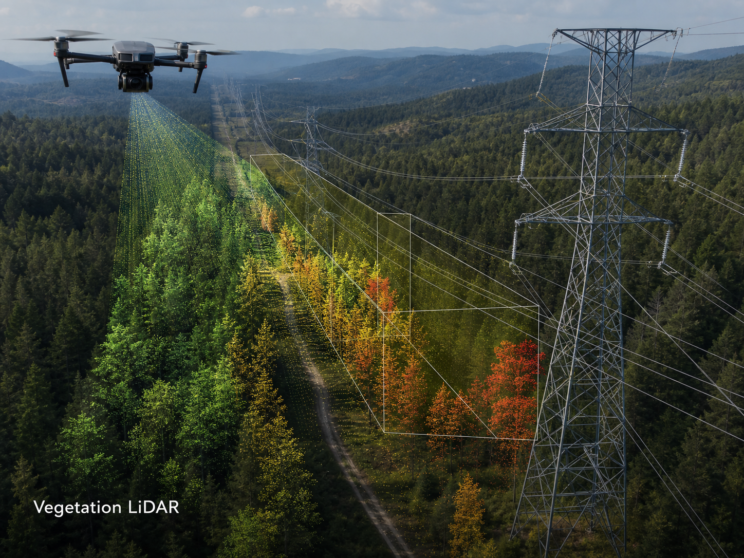
What drone LiDAR actually measures
A drone-mounted LiDAR system fires laser pulses downward at high frequency, measures the time-of-flight of each return, and builds a 3D point cloud of everything the laser reaches — conductors, structures, terrain, and vegetation. Modern systems capture millions of points per pass with centimetre-level accuracy, enabling direct measurement of:
- Vertical clearance between conductors and vegetation beneath.
- Horizontal clearance between conductors and vegetation alongside.
- Conductor sag at the time of capture, with ambient conditions documented for thermal-rating analysis.
- Vegetation height and growth trajectory across repeat captures.
- Encroachment of vegetation toward the operating envelope of the line.
The key technical advantage over photogrammetry for this application is that LiDAR can penetrate vegetation canopy and return points from the ground beneath. A photogrammetric capture of a forested corridor shows the canopy top; a LiDAR capture shows the canopy and the terrain underneath, allowing accurate vegetation height calculation across the corridor.
For NERC FAC-003-4 compliance work, which requires utilities to maintain documented clearance from vegetation across transmission lines operating at 200 kV and above, this distinction is operationally critical. Photogrammetry can supplement; LiDAR is the survey-grade measurement.
What the operational programs look like
Mature drone LiDAR vegetation programs run on an annual or semi-annual cadence across the high-priority transmission portfolio. The structure varies by utility, but a common pattern includes:
- Annual full-corridor capture of the high-risk transmission portfolio — typically the lines in fire-prone zones, lines with vegetation contact history, and lines approaching renewal.
- Targeted re-capture of corridors where the prior year’s analysis identified accelerated growth, encroachment, or marginal clearance.
- Post-event capture following storms, fires, or significant weather, particularly where the asset team needs rapid clearance and condition data for re-energising decisions.
- Pre-trim and post-trim capture around scheduled vegetation work — measuring the starting condition and verifying the work was completed to specification.
Performance from utilities running mature programs is significant. Reported figures include 10× more corridor inspected per crew day and up to 60% reduction in vegetation-related outages compared to ground-only inspection. Anomaly detection times have moved from quarterly inspection cycles to near-continuous monitoring on the most critical assets.
Where the analysis is more important than the flight
The flight produces a point cloud. The point cloud becomes operationally useful through analysis — and the analysis software is where the gap between programs that perform and programs that produce data has been widening.
A useful LiDAR vegetation analysis pipeline includes:
- Classification of points into ground, vegetation, structure, conductor, and other categories.
- Conductor extraction with span-by-span identification.
- Clearance calculation between conductors and vegetation, evaluated against the asset owner’s clearance standard (typically NERC-derived for higher-voltage lines, utility-specific for lower-voltage).
- Encroachment ranking of identified vegetation against priority, by clearance margin and growth trajectory.
- Reporting in the asset GIS — outputs land in the work-management system as ranked work orders, not as a PDF report.
Several specialist platforms have emerged in this space, and California utilities in particular have built large operational programs on top of recurring drone LiDAR capture combined with analysis software that ranks vegetation work by risk and clearance.
“The flight is the cheap part of this program,” Gray notes. “The repeat-frequency, the analysis pipeline, and the integration with the work-management system are what determine whether the program actually reduces outages and risk. Utilities who get the flight right and the analysis wrong end up with the most expensive collection of unused point clouds in the industry.”
Compliance, but framed correctly
NERC FAC-003 sets the regulatory floor for transmission vegetation management on lines 200 kV and above. The standard requires utilities to maintain minimum vegetation clearance distances, with documentation that the program is being executed and that no encroachment within the minimum clearance distance has occurred.
Drone LiDAR provides the most defensible documentation method available for the measurement side of this requirement. A clean drone LiDAR pass with documented analysis is a stronger compliance record than the historical methods (visual ground inspection, aerial helicopter survey, sample measurement), and the time-stamped point cloud is auditable in a way that ground inspection notes are not.
For lines below 200 kV, FAC-003 does not directly apply, but utility-specific clearance standards and state-level reliability standards often do. The same documentation logic applies — the drone LiDAR record is auditable evidence of measurement and condition at a known date.
“The compliance value is real, but it is not the leading reason to run the program,” Gray says. “The leading reason is that the data is good enough to drive operational decisions in a way ground inspection alone cannot match. The compliance documentation falls out of running the program well. Programs that are built primarily for compliance tend to produce less operational value than programs that are built for clearance management and produce compliance documentation as a byproduct.”
Where the cost case sits
The cost case for drone LiDAR on transmission corridor vegetation work depends on the scale and prior method.
Compared to helicopter LiDAR, drone LiDAR is typically cheaper per mile for shorter corridors and segmented work, and more expensive per mile for very long, continuous corridors. The break-even depends on the operator and the geography, but for most utilities the two methods are complementary — helicopter for the large annual sweep, drone for the targeted re-fly, post-event capture, and asset-specific deeper looks.
Compared to ground-based clearance survey, drone LiDAR is faster, safer, and produces a more comprehensive record. The flight-day cost is higher than a ground inspection on a per-segment basis, but the deliverable supports a much broader analysis and the inspection rate per crew day is materially higher.
For most utilities, the right answer is a mixed program — helicopter for large-scale sweeps where it makes economic sense, drone for the targeted, repeat, and event-driven work, ground inspection for the close-up assessment of identified high-risk sites.
A practical specification for transmission LiDAR work
When commissioning drone LiDAR for transmission vegetation management, the scope should address:
- Corridor list and priority ranking, with voltage class for each line.
- Capture cadence — annual full-corridor, plus targeted re-capture and event-driven.
- Point density requirement — typically 80+ points per square metre for clearance work, higher for detailed structural analysis.
- Accuracy requirement — typically 5 to 10 cm horizontal and vertical, with documented checkpoints.
- Classification standard — points classified into ground, vegetation, structure, conductor, with the classification scheme matched to the analysis software.
- Clearance analysis — measured against the asset owner’s clearance standard, with encroachment ranking.
- Output format and integration — work orders ranked by risk landing in the asset management system, not a standalone PDF.
- Ambient conditions documentation — temperature, time of day, wind, for conductor sag interpretation.
- Safety integration — coordination with the transmission control centre, switching plan alignment for any flights within minimum approach distances.
A scope that addresses these turns into a program that materially reduces outage risk, supports a clean compliance record, and integrates with the operational workflow. A scope that addresses only the flight produces data the asset team will not be able to act on at the speed the risk environment now requires.
The technology is mature. The programs that perform are the ones that treat the flight as one input into a working vegetation management pipeline — not as the deliverable itself.