Drone Progress Monitoring on Construction Sites: What Works and What to Avoid
A field-tested look at how drone capture supports construction progress monitoring — what to fly, how often, what to deliver, and where the program adds real value versus generating photos that no one uses.
Drone-based progress monitoring is one of the more mature applications of aerial capture on infrastructure projects. The business case is clear, the technology is well understood, and most project teams have either used it directly or seen it on another job. But the gap between projects that get strong value from it and projects that produce a folder of impressive aerial photos no one references is wide — and most of that gap is set in the first scoping conversation.
This post is about what makes a drone progress monitoring program useful, and what to specify so the deliverables land in the project workflow rather than the project archive.
The business case is real, but the implementations vary
The market backdrop is straightforward. The global construction drone market is projected to reach roughly $15.5 billion by 2032, driven by the kind of efficiency and safety gains construction managers have been quantifying for several years. According to the Construction Management Association of America, 51% of small construction business owners cite site inspection as a top benefit of drone technology.
The flight-day economics are well-established. What varies is whether the data lands in a system that drives decisions or sits in a folder.
“Construction progress monitoring is one of the few drone applications where we still see clients commission flights without a clear plan for the data,” says Hunter Gray, founder of Overwatch Mapping. “The flight is easy. The decision the flight is supposed to support is the part that gets skipped.”
Without that grounding, the program turns into recurring photography. With it, the program turns into a continuous record that drives weekly planning meetings, contractor invoicing, and capital draws.
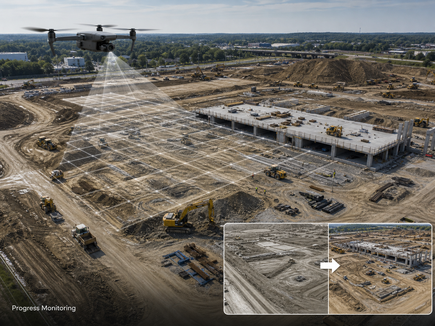
What a progress monitoring flight actually captures
A useful progress monitoring program captures three layers on every flight:
- An orthomosaic of the active site, geo-referenced and accurately scaled, suitable for measurement and overlay against design.
- A consistent oblique image set — typically four to eight angles, taken from the same positions each visit, that supports rapid visual comparison week over week.
- Optional 3D capture (DSM, point cloud, or mesh) on flights where volumetric measurement, terrain change, or design-overlay work is required.
Repeat capture from consistent positions is what makes the data comparable. Drone flights that look beautiful but capture the site from different angles each visit produce material that is useful for marketing and almost useless for project control.
How often to fly
The right cadence depends on the project phase and the decisions the data drives.
Earthworks and bulk-cut phases: fortnightly or weekly. Volumetric change matters, ground conditions change quickly, and the data feeds directly into contractor measurement and progress claims.
Structural and vertical-build phases: weekly is common, fortnightly for slower-progressing work. Visual progress is the primary deliverable; volumetric change is less central.
Fit-out and final phases: monthly, or event-driven. The exterior change has slowed, and the value moves to documentation and handover capture.
Event-driven capture sits across all phases — incidents, milestones, weather events, sign-off points. These flights are scoped on a per-event basis and supplement the recurring cadence.
A fixed cadence is more valuable than an over-engineered one. Consistent every-two-week capture across a 14-month project produces a comparable record that drives weekly planning. Variable, slip-when-busy capture produces a partial record that drives much less.
Where the value actually shows up
When clients describe the value of a well-run progress monitoring program, the same five categories come up:
Progress claim verification. Drone-derived orthomosaics with measured progress against schedule give the project team an independent reference for contractor claims, particularly for earthworks and exterior progress. The disagreement that used to need a site walk now needs a layer comparison in the project software.
Earthworks volume tracking. Drone-derived volumes routinely come within 1 to 3% of survey-grade ground truth on well-controlled flights — accurate enough for monthly progress measurement at a fraction of the cost of total-station survey.
Schedule communication. A current orthomosaic with progress annotation goes to the project board, the client, the lender, and the consenting authority. It is a higher-quality and lower-effort communication tool than a deck of phone photos.
Issue and incident documentation. A weekly visual baseline means that when an issue is reported, the team has imagery from before, during, and after — invaluable for warranty, insurance, and dispute work.
Safety and access planning. Aerial visibility of plant movements, access routes, and exclusion zones supports safety briefings and access change decisions. This is a secondary benefit but a consistent one.
What separates programs that work from programs that don’t
A program produces value when these things are true:
- A named owner of the data on the project team. Usually the project engineer or planner. Their job includes ingesting and using the weekly capture, not just receiving it.
- A consistent capture protocol. Same positions, same overlap, same processing parameters every visit. The provider should run a documented capture plan.
- A defined integration with the project software. The orthomosaic lands in the project management platform, the BIM coordination tool, or the planning software — not in a SharePoint folder no one opens.
- Defined deliverable formats matched to the receiving systems.
- A scope conversation that started with the decisions the data supports.
“On the projects where the program adds real value, there is a person on the client side whose job is to use the data,” Gray notes. “On the projects where it doesn’t, the data is being sent to a distribution list and no one in particular owns it. The pattern is consistent enough that we ask about the named data owner in scoping now.”
Where the program tends to be over-scoped
Three common over-scopes show up enough to be worth flagging:
Capture frequency too high for the phase. Weekly flights during slow fit-out generate data faster than the team can use it, and the program loses momentum because the value-per-flight drops.
3D capture every visit. Detailed 3D models are valuable on specific flights; producing them weekly when they are not being used costs processing time and adds to the deliverable size without supporting any decision.
Too much oblique variety. A consistent set of eight obliques is more useful than a fresh creative set every visit. The comparison value depends on the consistency.
In each case, the over-scope tends to come from treating the drone work as a service line rather than as a data feed into a decision process. Scoping back to what the team actually uses usually improves the program rather than diminishes it.
A note on safety and live-site integration
Construction sites are live environments with plant, personnel, and changing conditions. Drone operations need to integrate with the principal contractor’s safety plan, induction process, and exclusion zone management. This is not optional and not a check-the-box exercise.
“On a live construction site, the drone operation is part of the safety brief,” Gray says. “The crew is inducted, the flight zone is communicated, the operation is visible to other personnel, and the flight plan is downstream of the day’s plant movements. Any provider who shows up and starts flying without that integration is the wrong provider for the job.”
The contractor or principal designer’s safety expectations are the operating standard, not the Part 107 minimum.
A practical scope for a progress monitoring program
When commissioning a drone progress monitoring program, the scope should specify:
- Project phase and expected duration — informs cadence and deliverable mix.
- Recurring capture cadence — typically weekly or fortnightly.
- Capture protocol — consistent flight paths and oblique positions, documented.
- Deliverables per flight — orthomosaic at a defined GSD, oblique set, optional 3D capture per phase.
- Integration target — which project software the data lands in, in what format.
- CRS and accuracy — survey-grade or mapping-grade, with target CRS specified.
- Event-driven capture provisions — how out-of-cadence flights are commissioned.
- Safety integration — induction, access, exclusion zone management.
That scope produces a program that drives decisions for the life of the project. A scope that addresses two or three of these produces capture that is technically correct and operationally underused.
The drone work is the easy part. The work around it is what determines whether the program is paying for itself.